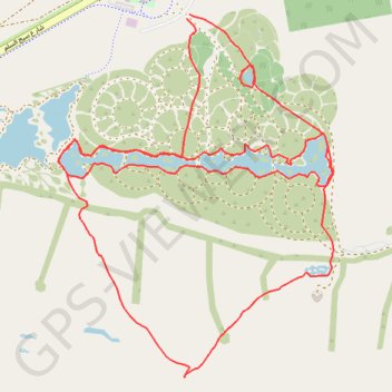
ACTIVE LOG 001
- Distance: 12.4 Km
- Elevation gain: 60 m
- Maximum elevation: 106 m
- Elevation loss: 59 m
- Minimum elevation: 85 m
- Moving time: 1 h 13 m
- Moving speed: 10.1 Km/h
- Maximum speed: 28.9 Km/h
- Total time: 1 h 23 m
- Global speed: 9.0 Km/h
Interactive trail map
Trail profile
- Distance: 12.4 Km
- Elevation gain: 60 m
- Maximum elevation: 106 m
- Elevation loss: 59 m
- Minimum elevation: 85 m
- Moving time: 1 h 13 m
- Moving speed: 10.1 Km/h
- Maximum speed: 28.9 Km/h
- Total time: 1 h 23 m
- Global speed: 9.0 Km/h
About this trail
Name: ACTIVE LOG 001 trail, distance, elevation, map, profile, GPS track
Start: Saih Al Salam, Dubai, United Arab Emirates (24.84836 55.34767)
End: Saih Al Salam, Dubai, United Arab Emirates (24.84857 55.34781)
Coordinates: 24.82743 55.33938 24.84857 55.35710
Other hiking, mountain biking, running and outdoor activity trails
Click on a trail to view its statistics, map and profile.
The Stick got me
United Arab Emirates > Dubai > Al Yalayis 3
Distance: 107.0 Km • Elevation gain: 435 m • Maximum elevation: 110 m