Cave-tastic
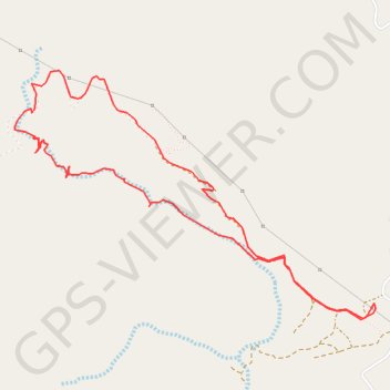
- Distance: 8.1 Km
- Elevation gain: 444 m
- Maximum elevation: 619 m
- Elevation loss: 444 m
- Minimum elevation: 390 m
- Moving time: 1 h 19 m
- Moving speed: 6.2 Km/h
- Maximum speed: 12.5 Km/h
- Total time: 1 h 19 m
- Global speed: 6.2 Km/h
Interactive trail map
Trail profile
- Distance: 8.1 Km
- Elevation gain: 444 m
- Maximum elevation: 619 m
- Elevation loss: 444 m
- Minimum elevation: 390 m
- Moving time: 1 h 19 m
- Moving speed: 6.2 Km/h
- Maximum speed: 12.5 Km/h
- Total time: 1 h 19 m
- Global speed: 6.2 Km/h
About this trail
Name: Cave-tastic trail, distance, elevation, map, profile, GPS track
Start: Deira Al-Tamba, Tawyeen, Fujairah Emirate, United Arab Emirates (25.60787 56.12212)
End: Deira Al-Tamba, Tawyeen, Fujairah Emirate, United Arab Emirates (25.60794 56.12211)
Coordinates: 25.60690 56.09743 25.62233 56.12220