Thank you for supporting this site ❤️
Make a donation
Make a donation
Gear up for your next adventure:
As an Amazon Associate, this site earns from qualifying purchases at no extra cost to you.
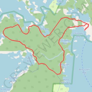
Georgian Bay Islands National Park
Lake Huron. Beausoleil Island. #Hiking #Loop #Georgian #Beausoleil #Huron
- Distance: 8.0 Km
- Elevation gain: 61 m
- Maximum elevation: 195 m
- Elevation loss: 62 m
- Minimum elevation: 178 m
Interactive trail map
Thank you for supporting this site ❤️
Make a donation
Make a donation
Gear up for your next adventure:
As an Amazon Associate, this site earns from qualifying purchases at no extra cost to you.
Trail profile
- Distance: 8.0 Km
- Elevation gain: 61 m
- Maximum elevation: 195 m
- Elevation loss: 62 m
- Minimum elevation: 178 m
Thank you for supporting this site ❤️
Make a donation
Make a donation
Gear up for your next adventure:
As an Amazon Associate, this site earns from qualifying purchases at no extra cost to you.
About this trail
Name: Georgian Bay Islands National Park trail, distance, elevation, map, profile, GPS track
Coordinates: 44.87917 -79.87837 44.89339 -79.84839
Thank you for supporting this site ❤️
Make a donation
Make a donation
Gear up for your next adventure:
As an Amazon Associate, this site earns from qualifying purchases at no extra cost to you.
Other hiking, mountain biking, running and outdoor activity trails
Click on a trail to view its statistics, map and profile.