Make a donation
Gear up for your next adventure:
As an Amazon Associate, this site earns from qualifying purchases at no extra cost to you.
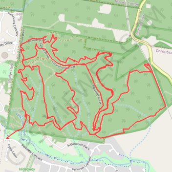
Cornubia Forest Nature Reserve
Interactive trail map
Make a donation
Gear up for your next adventure:
As an Amazon Associate, this site earns from qualifying purchases at no extra cost to you.
Trail profile
- Distance: 17.0 Km
- Elevation gain: 518 m
- Maximum elevation: 144 m
- Elevation loss: 522 m
- Minimum elevation: 23 m
Make a donation
Gear up for your next adventure:
As an Amazon Associate, this site earns from qualifying purchases at no extra cost to you.
About this trail
Name: Cornubia Forest Nature Reserve trail, distance, elevation, map, profile, GPS track
Start: Parkview Access Trail, Cornubia, Greater Brisbane, Queensland, 4130, Australia (-27.65234 153.19379)
End: Parkview Crescent, Cornubia, Greater Brisbane, Queensland, 4130, Australia (-27.65450 153.19196)
Coordinates: -27.65453 153.19163 -27.64377 153.20996
Topography: Queensland topographic map, elevation, terrain
Make a donation
Gear up for your next adventure:
As an Amazon Associate, this site earns from qualifying purchases at no extra cost to you.