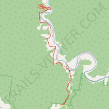
Drummers Fire Trail
- Distance: 16.6 Km
- Elevation gain: 308 m
- Maximum elevation: 274 m
- Elevation loss: 308 m
- Minimum elevation: 173 m
- Moving time: 1 h 58 m
- Moving speed: 8.4 Km/h
- Maximum speed: 16.6 Km/h
- Total time: 2 h 6 s
- Global speed: 8.3 Km/h
Interactive trail map
Trail profile
- Distance: 16.6 Km
- Elevation gain: 308 m
- Maximum elevation: 274 m
- Elevation loss: 308 m
- Minimum elevation: 173 m
- Moving time: 1 h 58 m
- Moving speed: 8.4 Km/h
- Maximum speed: 16.6 Km/h
- Total time: 2 h 6 s
- Global speed: 8.3 Km/h
About this trail
Name: Drummers Fire Trail trail, distance, elevation, map, profile, GPS track
Start: Bylong Valley Way, Mid-Western Regional Council, New South Wales, Australia (-32.39734 150.26971)
End: Bylong Valley Way, Mid-Western Regional Council, New South Wales, Australia (-32.39742 150.26968)
Coordinates: -32.39742 150.25686 -32.35230 150.27464
Topography: New South Wales topographic map, elevation, terrain
Other hiking, mountain biking, running and outdoor activity trails
Click on a trail to view its statistics, map and profile.
Broadmeadow - Gulgong - Merrygoen - Dubbo railway
Australia > New South Wales > Newcastle
AU, NSW, railway
Distance: 374.4 Km • Elevation gain: 2,635 m • Maximum elevation: 504 m
Broadmeadow - Gulgong - Merrygoen - Dubbo railway
Australia > New South Wales > Newcastle
AU, NSW, railway
Distance: 375.3 Km • Elevation gain: 2,641 m • Maximum elevation: 517 m