Magothy Greenway Yellow/Blue
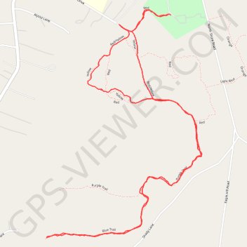
Interactive trail map
Trail profile
- Distance: 5.2 Km
- Elevation gain: 19 m
- Maximum elevation: 16 m
- Elevation loss: 19 m
- Minimum elevation: 5 m
- Moving time: 1 h 21 m
- Moving speed: 3.9 Km/h
- Maximum speed: 16.6 Km/h
- Total time: 1 h 33 m
- Global speed: 3.4 Km/h
About this trail
Name: Magothy Greenway Yellow/Blue trail, distance, elevation, map, profile, GPS track
Start: Red, Lyndale, Lake Shore, Anne Arundel County, Maryland, 21122, United States (39.10371 -76.48945)
End: Red, Lyndale, Lake Shore, Anne Arundel County, Maryland, 21122, United States (39.10375 -76.48959)
Coordinates: 39.09321 -76.49709 39.10398 -76.48759
Other hiking, mountain biking, running and outdoor activity trails
Click on a trail to view its statistics, map and profile.
Magothy Greenway Trails
United States > Maryland > Anne Arundel County > Lake Shore > Lyndale
Distance: 9.0 Km • Elevation gain: 37 m • Maximum elevation: 20 m