Lone Eagle Peak - Pawnee Pass
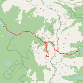
From the Lake Granby side, this traverse begins near Monarch Lake and follows the Cascade Creek corridor into the Indian Peaks Wilderness, passing forested shoreline, Arapaho Pass Trail junction, Buchanan Creek, Cascade Creek, and waterfall-lined sections of the valley.
Beyond the Cascade Creek basin, the route reaches the Mirror Lake and Crater Lake area beneath the dramatic granite profile of Lone Eagle Peak, then turns back toward the high alpine country of Triangle Lake and Pawnee Lake before climbing toward Pawnee Pass.
After crossing the Continental Divide at Pawnee Pass, the trail descends through open tundra, rocky slopes, and subalpine meadows toward Lake Isabelle, then follows the valley past Long Lake to finish at the Long Lake Trailhead in the Brainard Lake Recreation Area.
#Hiking #Rockies #Wilderness #Mountains #Alpine #Lakes #Forest
- Distance: 32.9 Km
- Elevation gain: 2,006 m
- Maximum elevation: 3,824 m
- Elevation loss: 1,338 m
- Minimum elevation: 2,535 m
Interactive trail map
Trail profile
- Distance: 32.9 Km
- Elevation gain: 2,006 m
- Maximum elevation: 3,824 m
- Elevation loss: 1,338 m
- Minimum elevation: 2,535 m
About this trail
Name: Lone Eagle Peak - Pawnee Pass trail, distance, elevation, map, profile, GPS track
Coordinates: 40.06619 -105.75865 40.11980 -105.58380
Other hiking, mountain biking, running and outdoor activity trails
Click on a trail to view its statistics, map and profile.
Lake Isabelle, Long Lake, and Brainard Lake Loop in Indian Peaks Wilderness
United States > Colorado > Boulder County
The Lake Isabelle, Long Lake, and Brainard Lake Loop in Colorado's Indian Peaks Wilderness offers hikers a journey through diverse landscapes, including wildflower meadows, subalpine forests, and mountain vistas. Along the trail, one can observe Long Lake and Lake Isabelle, both set against a backdrop of…
Distance: 10.1 Km • Elevation gain: 238 m • Maximum elevation: 3,339 m