Thank you for supporting this site ❤️
Make a donation
Make a donation
Gear up for your next adventure:
As an Amazon Associate, this site earns from qualifying purchases at no extra cost to you.
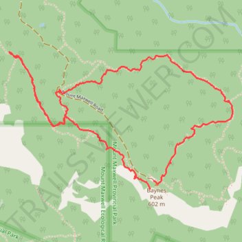
2026-06-13_12-50_Sat
- Distance: 4.3 Km
- Elevation gain: 268 m
- Maximum elevation: 577 m
- Elevation loss: 239 m
- Minimum elevation: 472 m
- Moving time: 1 h 17 m
- Moving speed: 3.4 Km/h
- Maximum speed: 5.9 Km/h
- Total time: 1 h 38 m
- Global speed: 2.6 Km/h
Interactive trail map
Thank you for supporting this site ❤️
Make a donation
Make a donation
Gear up for your next adventure:
As an Amazon Associate, this site earns from qualifying purchases at no extra cost to you.
Trail profile
- Distance: 4.3 Km
- Elevation gain: 268 m
- Maximum elevation: 577 m
- Elevation loss: 239 m
- Minimum elevation: 472 m
- Moving time: 1 h 17 m
- Moving speed: 3.4 Km/h
- Maximum speed: 5.9 Km/h
- Total time: 1 h 38 m
- Global speed: 2.6 Km/h
Thank you for supporting this site ❤️
Make a donation
Make a donation
Gear up for your next adventure:
As an Amazon Associate, this site earns from qualifying purchases at no extra cost to you.
About this trail
Name: 2026-06-13_12-50_Sat trail, distance, elevation, map, profile, GPS track
Coordinates: 48.80137 -123.52772 48.80806 -123.51111
Thank you for supporting this site ❤️
Make a donation
Make a donation
Gear up for your next adventure:
As an Amazon Associate, this site earns from qualifying purchases at no extra cost to you.
Other hiking, mountain biking, running and outdoor activity trails
Click on a trail to view its statistics, map and profile.
BBF loop to the Skydeck in Nanaimo
Canada > British Columbia > Cowichan Valley Regional District > Area A (Mill Bay / Malahat) > Mill Bay
BBF loop to the Skydeck
Distance: 323.5 Km • Elevation gain: 6,222 m • Maximum elevation: 706 m