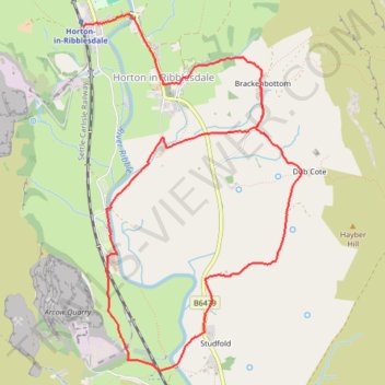
Horton in Ribblesdale loop walk
- Distance: 8.2 Km
- Elevation gain: 132 m
- Maximum elevation: 287 m
- Elevation loss: 112 m
- Minimum elevation: 220 m
- Moving time: 2 h 16 m
- Moving speed: 3.6 Km/h
- Maximum speed: 8.0 Km/h
- Total time: 2 h 27 m
- Global speed: 3.3 Km/h
Interactive trail map
Trail profile
- Distance: 8.2 Km
- Elevation gain: 132 m
- Maximum elevation: 287 m
- Elevation loss: 112 m
- Minimum elevation: 220 m
- Moving time: 2 h 16 m
- Moving speed: 3.6 Km/h
- Maximum speed: 8.0 Km/h
- Total time: 2 h 27 m
- Global speed: 3.3 Km/h
About this trail
Name: Horton in Ribblesdale loop walk trail, distance, elevation, map, profile, GPS track
Coordinates: 54.12640 -2.30173 54.14966 -2.27747
Other hiking, mountain biking, running and outdoor activity trails
Click on a trail to view its statistics, map and profile.
Pen-y-ghent, Foxup Road, Hull Pot and Horton Scar Lane Loop Hike
United Kingdom > England > North Yorkshire > Horton in Ribblesdale
Distance: 14.6 Km • Elevation gain: 554 m • Maximum elevation: 694 m