Import a GPX file

Grays Peak

Hike from Big Bear Lake to Grays Peak in the San Bernardino National Forest. #Hiking #Mountain #Lake #Forest #Nature

  • Distance: 5.6 Km
  • Elevation gain: 373 m
  • Maximum elevation: 2,410 m
  • Elevation loss: 29 m
  • Minimum elevation: 2,064 m

Interactive trail map
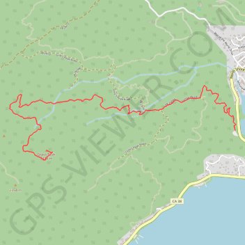
Trail profile

  • Distance: 5.6 Km
  • Elevation gain: 373 m
  • Maximum elevation: 2,410 m
  • Elevation loss: 29 m
  • Minimum elevation: 2,064 m

About this trail

Gear up for your next adventure:

📚Map Reading & Navigation Guides - Master the art of interpreting topographic contours and symbols
📻Handheld UHF Radios - Critical communication for groups in the Australian outback
🧰Survival Kits - Essential survival gear
🧥Thermal Emergency Blankets - Compact Mylar blankets to prevent hypothermia if stranded overnight
🌬️Windbreaker Jackets - Wind protection jackets

As an Amazon Associate, this site earns from qualifying purchases at no extra cost to you.