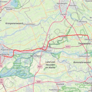
Track 20240108-104611
- Distance: 49.4 Km
- Elevation gain: 93 m
- Maximum elevation: 11 m
- Elevation loss: 89 m
- Minimum elevation: -3 m
Interactive trail map
Trail profile
- Distance: 49.4 Km
- Elevation gain: 93 m
- Maximum elevation: 11 m
- Elevation loss: 89 m
- Minimum elevation: -3 m
About this trail
Name: Track 20240108-104611 trail, distance, elevation, map, profile, GPS track
Coordinates: 51.80138 4.67002 51.89973 5.27090
Other hiking, mountain biking, running and outdoor activity trails
Click on a trail to view its statistics, map and profile.
Eurovelo 15 - Strasbourg Rotterdam
France > Grand Est > Bas-Rhin > Strasbourg
Distance: 891.7 Km • Elevation gain: 2,104 m • Maximum elevation: 146 m
LF tour 100 KM
Netherlands > South Holland > Rotterdam
Distance: 100.4 Km • Elevation gain: 188 m • Maximum elevation: 15 m