Manly Dam MTB Loop Trail
- Distance: 13.2 Km
- Elevation gain: 188 m
- Maximum elevation: 148 m
- Elevation loss: 192 m
- Minimum elevation: 21 m
- Moving time: 1 h 16 m
- Moving speed: 10.4 Km/h
- Maximum speed: 30.6 Km/h
- Total time: 1 h 22 m
- Global speed: 9.6 Km/h
Interactive trail map
Trail profile
- Distance: 13.2 Km
- Elevation gain: 188 m
- Maximum elevation: 148 m
- Elevation loss: 192 m
- Minimum elevation: 21 m
- Moving time: 1 h 16 m
- Moving speed: 10.4 Km/h
- Maximum speed: 30.6 Km/h
- Total time: 1 h 22 m
- Global speed: 9.6 Km/h
About this trail
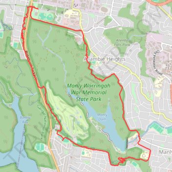
Name: Manly Dam MTB Loop Trail trail, distance, elevation, map, profile, GPS track
Coordinates: -33.78568 151.23159 -33.75546 151.26106
Topography: Sydney topographic map, elevation, terrain
Other hiking, mountain biking, running and outdoor activity trails
Click on a trail to view its statistics, map and profile.