Thank you for supporting this site ❤️
Make a donation
Make a donation
Gear up for your next adventure:
As an Amazon Associate, this site earns from qualifying purchases at no extra cost to you.
19 Dec. 2022 10:10:05 am
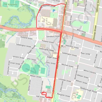
- Distance: 4.7 Km
- Elevation gain: 22 m
- Maximum elevation: 38 m
- Elevation loss: 21 m
- Minimum elevation: 23 m
- Moving time: 12 m 59 s
- Moving speed: 21.7 Km/h
- Maximum speed: 49.5 Km/h
- Total time: 35 m 23 s
- Global speed: 8.0 Km/h
Interactive trail map
Thank you for supporting this site ❤️
Make a donation
Make a donation
Gear up for your next adventure:
As an Amazon Associate, this site earns from qualifying purchases at no extra cost to you.
Trail profile
- Distance: 4.7 Km
- Elevation gain: 22 m
- Maximum elevation: 38 m
- Elevation loss: 21 m
- Minimum elevation: 23 m
- Moving time: 12 m 59 s
- Moving speed: 21.7 Km/h
- Maximum speed: 49.5 Km/h
- Total time: 35 m 23 s
- Global speed: 8.0 Km/h
Thank you for supporting this site ❤️
Make a donation
Make a donation
Gear up for your next adventure:
As an Amazon Associate, this site earns from qualifying purchases at no extra cost to you.
About this trail
Name: 19 Dec. 2022 10:10:05 am trail, distance, elevation, map, profile, GPS track
Coordinates: -33.78055 150.76869 -33.76561 150.77418
Topography: Sydney topographic map, elevation, terrain
Thank you for supporting this site ❤️
Make a donation
Make a donation
Gear up for your next adventure:
As an Amazon Associate, this site earns from qualifying purchases at no extra cost to you.
Other hiking, mountain biking, running and outdoor activity trails
Click on a trail to view its statistics, map and profile.