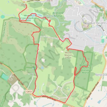
Lysterfield, Baluk William, Mount Morton, Birdsland
- Distance: 12.9 Km
- Elevation gain: 365 m
- Maximum elevation: 267 m
- Elevation loss: 427 m
- Minimum elevation: 111 m
- Moving time: 1 h 37 m
- Moving speed: 7.9 Km/h
- Maximum speed: 19.9 Km/h
- Total time: 1 h 46 m
- Global speed: 7.3 Km/h
Interactive trail map
Trail profile
- Distance: 12.9 Km
- Elevation gain: 365 m
- Maximum elevation: 267 m
- Elevation loss: 427 m
- Minimum elevation: 111 m
- Moving time: 1 h 37 m
- Moving speed: 7.9 Km/h
- Maximum speed: 19.9 Km/h
- Total time: 1 h 46 m
- Global speed: 7.3 Km/h
About this trail
Name: Lysterfield, Baluk William, Mount Morton, Birdsland trail, distance, elevation, map, profile, GPS track
Coordinates: -37.95153 145.32198 -37.91985 145.35018
Topography: Melbourne topographic map, elevation, terrain
Other hiking, mountain biking, running and outdoor activity trails
Click on a trail to view its statistics, map and profile.
Churchill National Park, Lysterfield Park
Australia > Victoria > Melbourne
Distance: 11.1 Km • Elevation gain: 387 m • Maximum elevation: 224 m
Upwey - Lysterfield Lake
Australia > Victoria > Melbourne
Distance: 24.5 Km • Elevation gain: 735 m • Maximum elevation: 211 m
Lysterfield Park
Australia > Victoria > Melbourne
Distance: 6.7 Km • Elevation gain: 209 m • Maximum elevation: 201 m