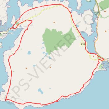
Corraun loop
- Distance: 37.7 Km
- Elevation gain: 346 m
- Maximum elevation: 48 m
- Elevation loss: 348 m
- Minimum elevation: 0 m
- Moving time: 2 h 16 m
- Moving speed: 16.5 Km/h
- Maximum speed: 34.6 Km/h
- Total time: 2 h 57 m
- Global speed: 12.8 Km/h
Interactive trail map
Trail profile
- Distance: 37.7 Km
- Elevation gain: 346 m
- Maximum elevation: 48 m
- Elevation loss: 348 m
- Minimum elevation: 0 m
- Moving time: 2 h 16 m
- Moving speed: 16.5 Km/h
- Maximum speed: 34.6 Km/h
- Total time: 2 h 57 m
- Global speed: 12.8 Km/h
About this trail
Name: Corraun loop trail, distance, elevation, map, profile, GPS track
Coordinates: 53.86670 -9.92724 53.95483 -9.78144
Other hiking, mountain biking, running and outdoor activity trails
Click on a trail to view its statistics, map and profile.
Connemara - Day 2
#Bike
Distance: 75.3 Km • Elevation gain: 797 m • Maximum elevation: 69 m