Thank you for supporting this site ❤️
Make a donation
Make a donation
Gear up for your next adventure:
As an Amazon Associate, this site earns from qualifying purchases at no extra cost to you.
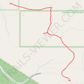
State Game Lands Number 34
- Distance: 13.6 Km
- Elevation gain: 231 m
- Maximum elevation: 665 m
- Elevation loss: 231 m
- Minimum elevation: 533 m
- Moving time: 1 h 40 m
- Moving speed: 8.1 Km/h
- Maximum speed: 19.2 Km/h
- Total time: 2 h 24 m
- Global speed: 5.6 Km/h
Interactive trail map
Thank you for supporting this site ❤️
Make a donation
Make a donation
Gear up for your next adventure:
As an Amazon Associate, this site earns from qualifying purchases at no extra cost to you.
Trail profile
- Distance: 13.6 Km
- Elevation gain: 231 m
- Maximum elevation: 665 m
- Elevation loss: 231 m
- Minimum elevation: 533 m
- Moving time: 1 h 40 m
- Moving speed: 8.1 Km/h
- Maximum speed: 19.2 Km/h
- Total time: 2 h 24 m
- Global speed: 5.6 Km/h
Thank you for supporting this site ❤️
Make a donation
Make a donation
Gear up for your next adventure:
As an Amazon Associate, this site earns from qualifying purchases at no extra cost to you.
About this trail
Name: State Game Lands Number 34 trail, distance, elevation, map, profile, GPS track
Coordinates: 41.25115 -78.38191 41.28219 -78.34774
Thank you for supporting this site ❤️
Make a donation
Make a donation
Gear up for your next adventure:
As an Amazon Associate, this site earns from qualifying purchases at no extra cost to you.