Thank you for supporting this site ❤️
Make a donation
Make a donation
Gear up for your next adventure:
As an Amazon Associate, this site earns from qualifying purchases at no extra cost to you.
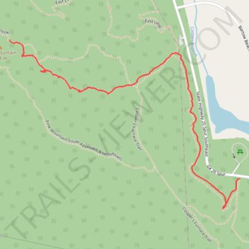
Pine Mountain South Approach B
- Distance: 2.0 Km
- Elevation gain: 191 m
- Maximum elevation: 453 m
- Elevation loss: 14 m
- Minimum elevation: 271 m
- Moving time: 37 m 30 s
- Moving speed: 3.1 Km/h
- Maximum speed: 6.5 Km/h
- Total time: 42 m 54 s
- Global speed: 2.8 Km/h
Interactive trail map
Thank you for supporting this site ❤️
Make a donation
Make a donation
Gear up for your next adventure:
As an Amazon Associate, this site earns from qualifying purchases at no extra cost to you.
Trail profile
- Distance: 2.0 Km
- Elevation gain: 191 m
- Maximum elevation: 453 m
- Elevation loss: 14 m
- Minimum elevation: 271 m
- Moving time: 37 m 30 s
- Moving speed: 3.1 Km/h
- Maximum speed: 6.5 Km/h
- Total time: 42 m 54 s
- Global speed: 2.8 Km/h
Thank you for supporting this site ❤️
Make a donation
Make a donation
Gear up for your next adventure:
As an Amazon Associate, this site earns from qualifying purchases at no extra cost to you.
About this trail
Name: Pine Mountain South Approach B trail, distance, elevation, map, profile, GPS track
Start: Connector, Bartow County, Georgia, United States (34.17156 -84.73431)
Coordinates: 34.17041 -84.74480 34.17676 -84.73431
Thank you for supporting this site ❤️
Make a donation
Make a donation
Gear up for your next adventure:
As an Amazon Associate, this site earns from qualifying purchases at no extra cost to you.