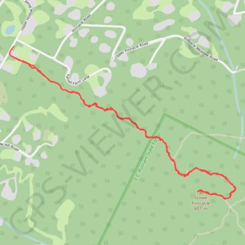
Stowe Pinnacle Trail in C.C. Putnam State Forest
The Stowe Pinnacle Trail offers an invigorating hike through a lush Vermont forest, leading to a rocky summit with expansive 360-degree views. From the peak, you can observe distant mountains like Camel’s Hump and Mount Mansfield, along with the sweeping Worcester Range. The trail is a mix of steep, rocky ascents and forested paths, rewarding hikers with one of the area's most iconic vistas at the top. #Hiking #Mountain #Overlook #Forest #Nature
- Distance: 5.4 Km
- Elevation gain: 458 m
- Maximum elevation: 783 m
- Elevation loss: 463 m
- Minimum elevation: 338 m
- Moving time: 2 h 22 m
- Moving speed: 2.3 Km/h
- Maximum speed: 10.0 Km/h
- Total time: 3 h 33 m
- Global speed: 1.5 Km/h
Interactive trail map
Trail profile
- Distance: 5.4 Km
- Elevation gain: 458 m
- Maximum elevation: 783 m
- Elevation loss: 463 m
- Minimum elevation: 338 m
- Moving time: 2 h 22 m
- Moving speed: 2.3 Km/h
- Maximum speed: 10.0 Km/h
- Total time: 3 h 33 m
- Global speed: 1.5 Km/h
About this trail
Name: Stowe Pinnacle Trail in C.C. Putnam State Forest trail, distance, elevation, map, profile, GPS track
Start: Stowe Pinnacle Trail, Stowe, Lamoille County, Vermont, United States (44.43867 -72.66739)
End: 527, Upper Hollow Road, Stowe, Lamoille County, Vermont, 05672, United States (44.43943 -72.66741)
Coordinates: 44.42934 -72.66782 44.43943 -72.64686
Other hiking, mountain biking, running and outdoor activity trails
Click on a trail to view its statistics, map and profile.
Stowe Pinnacle Trail via Pinnacle Meadow in C.C. Putnam State Forest
United States > Vermont > Lamoille County > Stowe
The Stowe Pinnacle Trail is a moderately challenging hike offering beautiful views of Vermont's Green Mountains. As hikers ascend through dense forests, the route rewards with striking vistas of Mount Mansfield, Camel's Hump, and the Worcester Range from the summit's rocky outcrop. The last stretch becomes…
Distance: 5.4 Km • Elevation gain: 319 m • Maximum elevation: 783 m