Coyote Song Trail and Swallow Trail Loop in South Valley Park
The Coyote Song and Swallow Trail Loop at South Valley Park offers a peaceful escape through meadows and striking red rock formations, typical of Colorado's Front Range. Hikers will enjoy expansive views of rolling hills and nearby foothills while traversing a mostly level, well-maintained path. It's an easy and scenic hike, making it ideal for families or those looking for a quick outdoor retreat. #Hiking #Loop #Rock #Nature
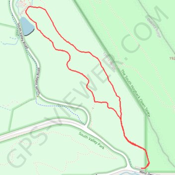
- Distance: 4.6 Km
- Elevation gain: 105 m
- Maximum elevation: 1,836 m
- Elevation loss: 107 m
- Minimum elevation: 1,754 m
- Moving time: 1 h 4 m
- Moving speed: 4.3 Km/h
- Maximum speed: 6.0 Km/h
- Total time: 1 h 4 m
- Global speed: 4.3 Km/h
Interactive trail map
Trail profile
- Distance: 4.6 Km
- Elevation gain: 105 m
- Maximum elevation: 1,836 m
- Elevation loss: 107 m
- Minimum elevation: 1,754 m
- Moving time: 1 h 4 m
- Moving speed: 4.3 Km/h
- Maximum speed: 6.0 Km/h
- Total time: 1 h 4 m
- Global speed: 4.3 Km/h
About this trail
Name: Coyote Song Trail and Swallow Trail Loop in South Valley Park trail, distance, elevation, map, profile, GPS track
Start: Coyote Song Trail, Jefferson County, Colorado, 80127, United States (39.55132 -105.13886)
End: Coyote Song Trail, Jefferson County, Colorado, 80127, United States (39.55127 -105.13930)
Coordinates: 39.55127 -105.15279 39.56587 -105.13835