Make a donation
Gear up for your next adventure:
As an Amazon Associate, this site earns from qualifying purchases at no extra cost to you.
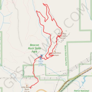
Hamilton Mountain Loop Trail via Little Hamilton Mountain and Hamilton Saddle
The Hamilton Mountain Loop Trail in Beacon Rock State Park offers a dynamic hiking experience with varied landscapes. Hikers can expect to pass through lush forests, with an abundance of wildflowers in spring and colorful leaves in fall, before reaching impressive views of the Columbia River Gorge and surrounding peaks. Along the way, you’ll encounter dramatic basalt cliffs, picturesque waterfalls like Rodney Falls, and panoramic vistas of Mount Hood and Table Mountain, making it a truly rewarding journey for those up for the challenge. #Hiking #Mountain #Forest #Nature #Overlook #Cliff #Waterfall
- Distance: 11.3 Km
- Elevation gain: 741 m
- Maximum elevation: 705 m
- Elevation loss: 731 m
- Minimum elevation: 123 m
Interactive trail map
Make a donation
Gear up for your next adventure:
As an Amazon Associate, this site earns from qualifying purchases at no extra cost to you.
Trail profile
- Distance: 11.3 Km
- Elevation gain: 741 m
- Maximum elevation: 705 m
- Elevation loss: 731 m
- Minimum elevation: 123 m
Make a donation
Gear up for your next adventure:
As an Amazon Associate, this site earns from qualifying purchases at no extra cost to you.
About this trail
Name: Hamilton Mountain Loop Trail via Little Hamilton Mountain and Hamilton Saddle trail, distance, elevation, map, profile, GPS track
End: Hamilton Mountain Trail, Skamania County, Washington, 97014, United States (45.63300 -122.01999)
Coordinates: 45.63261 -122.02014 45.66010 -122.00527
Make a donation
Gear up for your next adventure:
As an Amazon Associate, this site earns from qualifying purchases at no extra cost to you.
Other hiking, mountain biking, running and outdoor activity trails
Click on a trail to view its statistics, map and profile.
Hamilton Mountain Loop Trail via Hardy Falls, Rodney Falls and Hardy Creek
United States > Washington > Skamania County
The Hamilton Mountain Loop Trail in Beacon Rock State Park offers a rewarding experience for hikers seeking both natural beauty and a physical challenge. Along the way, hikers will encounter cascading waterfalls like Hardy Falls and Rodney Falls, each framed by lush greenery. The trail also provides panoramic…
Distance: 11.9 Km • Elevation gain: 790 m • Maximum elevation: 705 m
Northern part of the Pacific Crest Trail (PCT)
United States > Oregon > Klamath County
Hike on the Pacific Crest National Scenic Trail from Crater Lake to Canada Border through Oregon and Washington along the Sierra Nevada and Cascade mountain ranges. #Hiking #Mountain #SierraNevada #Cascade #Nature #Forest #Park #PCT
Distance: 1,198.3 Km • Elevation gain: 44,308 m • Maximum elevation: 2,307 m
Expedition to Sedum Ridge
United States > Oregon > Multnomah County > Portland
Distance: 214.7 Km • Elevation gain: 5,093 m • Maximum elevation: 1,169 m
Make a donation
Gear up for your next adventure:
As an Amazon Associate, this site earns from qualifying purchases at no extra cost to you.