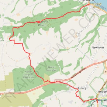
Hike from Sleights to Sandsend via Old Mulgrave Castle
- Distance: 11.4 Km
- Elevation gain: 281 m
- Maximum elevation: 261 m
- Elevation loss: 293 m
- Minimum elevation: 7 m
- Moving time: 2 h 44 m
- Moving speed: 4.2 Km/h
- Maximum speed: 8.1 Km/h
- Total time: 3 h 3 m
- Global speed: 3.7 Km/h
Interactive trail map
Trail profile
- Distance: 11.4 Km
- Elevation gain: 281 m
- Maximum elevation: 261 m
- Elevation loss: 293 m
- Minimum elevation: 7 m
- Moving time: 2 h 44 m
- Moving speed: 4.2 Km/h
- Maximum speed: 8.1 Km/h
- Total time: 3 h 3 m
- Global speed: 3.7 Km/h
About this trail
Name: Hike from Sleights to Sandsend via Old Mulgrave Castle trail, distance, elevation, map, profile, GPS track
Coordinates: 54.46001 -0.72636 54.50097 -0.66369