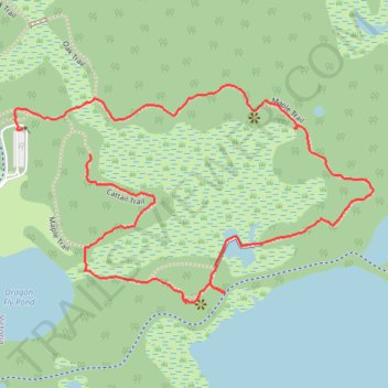
Maple Trail - Carver Park Reserve
- Distance: 2.3 Km
- Elevation gain: 21 m
- Maximum elevation: 298 m
- Elevation loss: 20 m
- Minimum elevation: 287 m
- Moving time: 44 m 20 s
- Moving speed: 3.2 Km/h
- Maximum speed: 15.2 Km/h
- Total time: 52 m 6 s
- Global speed: 2.7 Km/h
Interactive trail map
Trail profile
- Distance: 2.3 Km
- Elevation gain: 21 m
- Maximum elevation: 298 m
- Elevation loss: 20 m
- Minimum elevation: 287 m
- Moving time: 44 m 20 s
- Moving speed: 3.2 Km/h
- Maximum speed: 15.2 Km/h
- Total time: 52 m 6 s
- Global speed: 2.7 Km/h
About this trail
Name: Maple Trail - Carver Park Reserve trail, distance, elevation, map, profile, GPS track
Start: Cattail Trail, Victoria, Carver County, Minnesota, 55386, United States (44.88170 -93.68054)
End: Nature Center Drive, Victoria, Carver County, Minnesota, 55386, United States (44.88216 -93.68233)
Coordinates: 44.87899 -93.68248 44.88296 -93.67327
Other hiking, mountain biking, running and outdoor activity trails
Click on a trail to view its statistics, map and profile.