Thank you for supporting this site ❤️
Make a donation
Make a donation
Gear up for your next adventure:
As an Amazon Associate, this site earns from qualifying purchases at no extra cost to you.
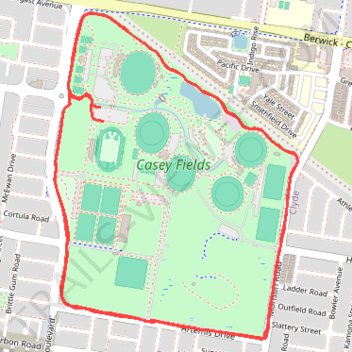
Casey Fields Loop
- Distance: 8.0 Km
- Elevation gain: 23 m
- Maximum elevation: 50 m
- Elevation loss: 23 m
- Minimum elevation: 43 m
- Moving time: 35 m 40 s
- Moving speed: 13.5 Km/h
- Maximum speed: 18.4 Km/h
- Total time: 35 m 40 s
- Global speed: 13.5 Km/h
Interactive trail map
Thank you for supporting this site ❤️
Make a donation
Make a donation
Gear up for your next adventure:
As an Amazon Associate, this site earns from qualifying purchases at no extra cost to you.
Trail profile
- Distance: 8.0 Km
- Elevation gain: 23 m
- Maximum elevation: 50 m
- Elevation loss: 23 m
- Minimum elevation: 43 m
- Moving time: 35 m 40 s
- Moving speed: 13.5 Km/h
- Maximum speed: 18.4 Km/h
- Total time: 35 m 40 s
- Global speed: 13.5 Km/h
Thank you for supporting this site ❤️
Make a donation
Make a donation
Gear up for your next adventure:
As an Amazon Associate, this site earns from qualifying purchases at no extra cost to you.
About this trail
Name: Casey Fields Loop trail, distance, elevation, map, profile, GPS track
Coordinates: -38.12846 145.30637 -38.11680 145.31740
Topography: Melbourne topographic map, elevation, terrain
Thank you for supporting this site ❤️
Make a donation
Make a donation
Gear up for your next adventure:
As an Amazon Associate, this site earns from qualifying purchases at no extra cost to you.