Make a donation
Gear up for your next adventure:
As an Amazon Associate, this site earns from qualifying purchases at no extra cost to you.
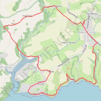
Mawnan Helford loop
- Distance: 11.6 Km
- Elevation gain: 281 m
- Maximum elevation: 97 m
- Elevation loss: 281 m
- Minimum elevation: 0 m
- Moving time: 1 h 21 m
- Moving speed: 8.6 Km/h
- Maximum speed: 15.6 Km/h
- Total time: 1 h 22 m
- Global speed: 8.5 Km/h
Interactive trail map
Make a donation
Gear up for your next adventure:
As an Amazon Associate, this site earns from qualifying purchases at no extra cost to you.
Trail profile
- Distance: 11.6 Km
- Elevation gain: 281 m
- Maximum elevation: 97 m
- Elevation loss: 281 m
- Minimum elevation: 0 m
- Moving time: 1 h 21 m
- Moving speed: 8.6 Km/h
- Maximum speed: 15.6 Km/h
- Total time: 1 h 22 m
- Global speed: 8.5 Km/h
Make a donation
Gear up for your next adventure:
As an Amazon Associate, this site earns from qualifying purchases at no extra cost to you.
About this trail
Name: Mawnan Helford loop trail, distance, elevation, map, profile, GPS track
Coordinates: 50.09955 -5.14465 50.12417 -5.10496
Make a donation
Gear up for your next adventure:
As an Amazon Associate, this site earns from qualifying purchases at no extra cost to you.
Other hiking, mountain biking, running and outdoor activity trails
Click on a trail to view its statistics, map and profile.
Durgan to Mawnan walk
United Kingdom > England > Cornwall > Mawnan Smith
Distance: 3.4 Km • Elevation gain: 112 m • Maximum elevation: 59 m
Mawnan Smith loop
United Kingdom > England > Cornwall > Falmouth > Bareppa
Cornwall Road Cycling
Distance: 54.9 Km • Elevation gain: 926 m • Maximum elevation: 202 m
Mawnan Smith Loop
United Kingdom > England > Cornwall > Falmouth > Carlidnack
Distance: 10.6 Km • Elevation gain: 263 m • Maximum elevation: 79 m