Thank you for supporting this site ❤️
Make a donation
Make a donation
Gear up for your next adventure:
As an Amazon Associate, this site earns from qualifying purchases at no extra cost to you.
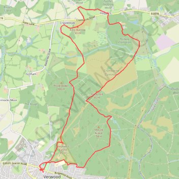
King Barrow Loop hike from Verwood
- Distance: 12.4 Km
- Elevation gain: 158 m
- Maximum elevation: 99 m
- Elevation loss: 158 m
- Minimum elevation: 42 m
- Moving time: 2 h 36 m
- Moving speed: 4.7 Km/h
- Maximum speed: 5.4 Km/h
- Total time: 2 h 36 m
- Global speed: 4.7 Km/h
Interactive trail map
Thank you for supporting this site ❤️
Make a donation
Make a donation
Gear up for your next adventure:
As an Amazon Associate, this site earns from qualifying purchases at no extra cost to you.
Trail profile
- Distance: 12.4 Km
- Elevation gain: 158 m
- Maximum elevation: 99 m
- Elevation loss: 158 m
- Minimum elevation: 42 m
- Moving time: 2 h 36 m
- Moving speed: 4.7 Km/h
- Maximum speed: 5.4 Km/h
- Total time: 2 h 36 m
- Global speed: 4.7 Km/h
Thank you for supporting this site ❤️
Make a donation
Make a donation
Gear up for your next adventure:
As an Amazon Associate, this site earns from qualifying purchases at no extra cost to you.
About this trail
Name: King Barrow Loop hike from Verwood trail, distance, elevation, map, profile, GPS track
Start: Potters Wheel, Howard Road, Verwood, Dorset, England, BH31 6ND, United Kingdom (50.88093 -1.87795)
End: Potters Wheel, Howard Road, Verwood, Dorset, England, BH31 6ND, United Kingdom (50.88093 -1.87793)
Coordinates: 50.88093 -1.87905 50.91350 -1.84798
Thank you for supporting this site ❤️
Make a donation
Make a donation
Gear up for your next adventure:
As an Amazon Associate, this site earns from qualifying purchases at no extra cost to you.