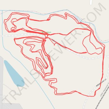
Momentum Bike Park - Southern Green Trails
- Distance: 9.2 Km
- Elevation gain: 34 m
- Maximum elevation: 286 m
- Elevation loss: 34 m
- Minimum elevation: 280 m
- Moving time: 34 m 25 s
- Moving speed: 16.0 Km/h
- Maximum speed: 32.7 Km/h
- Total time: 39 m 32 s
- Global speed: 13.9 Km/h
Interactive trail map
Trail profile
- Distance: 9.2 Km
- Elevation gain: 34 m
- Maximum elevation: 286 m
- Elevation loss: 34 m
- Minimum elevation: 280 m
- Moving time: 34 m 25 s
- Moving speed: 16.0 Km/h
- Maximum speed: 32.7 Km/h
- Total time: 39 m 32 s
- Global speed: 13.9 Km/h
About this trail
Name: Momentum Bike Park - Southern Green Trails trail, distance, elevation, map, profile, GPS track
Start: Adventure Ln, Joplin, Jasper County, Missouri, 64801, United States (37.10918 -94.51829)
End: Adventure Ln, Joplin, Jasper County, Missouri, 64801, United States (37.10916 -94.51833)
Coordinates: 37.10670 -94.52136 37.11075 -94.51526
Other hiking, mountain biking, running and outdoor activity trails
Click on a trail to view its statistics, map and profile.
Momentum Bike Park - Southwest Area
United States > Missouri > Jasper County > Joplin
Distance: 2.2 Km • Elevation gain: 19 m • Maximum elevation: 288 m