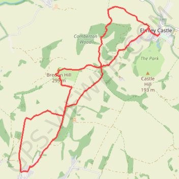
Elmley Castle
- Distance: 14.1 Km
- Elevation gain: 456 m
- Maximum elevation: 300 m
- Elevation loss: 454 m
- Minimum elevation: 59 m
Interactive trail map
Trail profile
- Distance: 14.1 Km
- Elevation gain: 456 m
- Maximum elevation: 300 m
- Elevation loss: 454 m
- Minimum elevation: 59 m
About this trail
Name: Elmley Castle trail, distance, elevation, map, profile, GPS track
Coordinates: 52.03818 -2.07777 52.07509 -2.02687
Other hiking, mountain biking, running and outdoor activity trails
Click on a trail to view its statistics, map and profile.
Ashton Under Hill
United Kingdom > England > Worcestershire > Wychavon > Ashton under Hill
Distance: 12.3 Km • Elevation gain: 268 m • Maximum elevation: 279 m