Make a donation
Gear up for your next adventure:
As an Amazon Associate, this site earns from qualifying purchases at no extra cost to you.
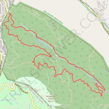
West Ridge, French and Stream Trails Loop in Reinhardt Redwood Regional Park
The West Ridge, French, and Stream Trails Loop in Reinhardt Redwood Regional Park offers hikers a serene journey through towering coast redwoods, providing ample shade and a tranquil atmosphere. As you navigate the well-marked paths, you'll encounter diverse flora, including ferns and wildflowers, and may spot local wildlife such as deer and squirrels. The loop also features sections alongside Redwood Creek, where the soothing sounds of flowing water enhance the peaceful experience. #Hiking #Loop #Forest #River #Nature
- Distance: 7.8 Km
- Elevation gain: 402 m
- Maximum elevation: 409 m
- Elevation loss: 402 m
- Minimum elevation: 231 m
- Moving time: 1 h 36 m
- Moving speed: 4.8 Km/h
- Maximum speed: 12.5 Km/h
- Total time: 1 h 36 m
- Global speed: 4.8 Km/h
Interactive trail map
Make a donation
Gear up for your next adventure:
As an Amazon Associate, this site earns from qualifying purchases at no extra cost to you.
Trail profile
- Distance: 7.8 Km
- Elevation gain: 402 m
- Maximum elevation: 409 m
- Elevation loss: 402 m
- Minimum elevation: 231 m
- Moving time: 1 h 36 m
- Moving speed: 4.8 Km/h
- Maximum speed: 12.5 Km/h
- Total time: 1 h 36 m
- Global speed: 4.8 Km/h
Make a donation
Gear up for your next adventure:
As an Amazon Associate, this site earns from qualifying purchases at no extra cost to you.
About this trail
Name: West Ridge, French and Stream Trails Loop in Reinhardt Redwood Regional Park trail, distance, elevation, map, profile, GPS track
Start: West Ridge Trail, Contra Costa County, California, 94516, United States (37.83141 -122.18526)
End: West Ridge Trail, Contra Costa County, California, 94516, United States (37.83142 -122.18522)
Coordinates: 37.81757 -122.18633 37.83142 -122.16513
Make a donation
Gear up for your next adventure:
As an Amazon Associate, this site earns from qualifying purchases at no extra cost to you.
Other hiking, mountain biking, running and outdoor activity trails
Click on a trail to view its statistics, map and profile.
Hike in Reinhardt-Redwood Regional Park
United States > California > Contra Costa County
Distance: 5.8 Km • Elevation gain: 243 m • Maximum elevation: 449 m
Loop hike in Reinhardt Redwood Regional Park
United States > California > Contra Costa County
Distance: 5.8 Km • Elevation gain: 210 m • Maximum elevation: 409 m
Make a donation
Gear up for your next adventure:
As an Amazon Associate, this site earns from qualifying purchases at no extra cost to you.