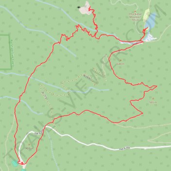
Oyster Dome loop hike via Lily Lake from Samish Overlook
- Distance: 10.6 Km
- Elevation gain: 430 m
- Maximum elevation: 633 m
- Elevation loss: 428 m
- Minimum elevation: 344 m
- Moving time: 4 h 4 m
- Moving speed: 2.6 Km/h
- Maximum speed: 9.9 Km/h
- Total time: 5 h 34 m
- Global speed: 1.9 Km/h
Interactive trail map
Trail profile
- Distance: 10.6 Km
- Elevation gain: 430 m
- Maximum elevation: 633 m
- Elevation loss: 428 m
- Minimum elevation: 344 m
- Moving time: 4 h 4 m
- Moving speed: 2.6 Km/h
- Maximum speed: 9.9 Km/h
- Total time: 5 h 34 m
- Global speed: 1.9 Km/h
About this trail
Name: Oyster Dome loop hike via Lily Lake from Samish Overlook trail, distance, elevation, map, profile, GPS track
Start: Larry Reed Trail, Samish, Skagit County, Washington, United States (48.60984 -122.42628)
End: DNR B-2000, Samish, Skagit County, Washington, United States (48.60988 -122.42624)
Coordinates: 48.60960 -122.42758 48.62716 -122.40362
Other hiking, mountain biking, running and outdoor activity trails
Click on a trail to view its statistics, map and profile.
Oyster Dome Trail in Blanchard State Forest
United States > Washington > Skagit County > Samish
The Oyster Dome Trail, accessed via Chuckanut Drive and the Samish Bay Connector, offers hikers a rewarding journey through Blanchard State Forest. The path meanders through lush forests of alder, cedar, and Douglas fir, with occasional views of the Salish Sea and the Olympic Peninsula. The trail culminates at…
Distance: 10.8 Km • Elevation gain: 614 m • Maximum elevation: 607 m
Oyster Dome via Chuckanut Trail and Samish Bay Connector in Blanchard State Forest
United States > Washington > Skagit County > Samish
The hike to Oyster Dome is a rewarding journey through the serene Blanchard State Forest. The route begins with steady switchbacks, winding through a lush canopy of Douglas fir, maple, and cedar, offering moments of tranquility punctuated by expansive views over Samish Bay. Upon reaching the rocky summit,…
Distance: 10.0 Km • Elevation gain: 606 m • Maximum elevation: 604 m
Oyster Dome Trail via Samish Bay Connector in Blanchard State Forest
United States > Washington > Skagit County > Samish
The Oyster Dome Trail offers a scenic and moderately challenging hike with rewarding views throughout. Starting from Samish Overlook, the route ascends through lush vegetation, including towering Douglas firs and cedar trees, leading hikers past impressive remnants of historical logging. Upon reaching the…
Distance: 7.0 Km • Elevation gain: 370 m • Maximum elevation: 607 m