Thank you for supporting this site ❤️
Make a donation
Make a donation
Gear up for your next adventure:
As an Amazon Associate, this site earns from qualifying purchases at no extra cost to you.
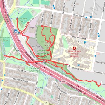
Greenslopes - Stephens Mountain
- Distance: 6.0 Km
- Elevation gain: 95 m
- Maximum elevation: 48 m
- Elevation loss: 95 m
- Minimum elevation: 10 m
- Moving time: 1 h 29 m
- Moving speed: 4.0 Km/h
- Maximum speed: 6.6 Km/h
- Total time: 1 h 31 m
- Global speed: 3.9 Km/h
Interactive trail map
Thank you for supporting this site ❤️
Make a donation
Make a donation
Gear up for your next adventure:
As an Amazon Associate, this site earns from qualifying purchases at no extra cost to you.
Trail profile
- Distance: 6.0 Km
- Elevation gain: 95 m
- Maximum elevation: 48 m
- Elevation loss: 95 m
- Minimum elevation: 10 m
- Moving time: 1 h 29 m
- Moving speed: 4.0 Km/h
- Maximum speed: 6.6 Km/h
- Total time: 1 h 31 m
- Global speed: 3.9 Km/h
Thank you for supporting this site ❤️
Make a donation
Make a donation
Gear up for your next adventure:
As an Amazon Associate, this site earns from qualifying purchases at no extra cost to you.
About this trail
Name: Greenslopes - Stephens Mountain trail, distance, elevation, map, profile, GPS track
Coordinates: -27.51590 153.03889 -27.50981 153.04862
Topography: City of Brisbane topographic map, elevation, terrain
Thank you for supporting this site ❤️
Make a donation
Make a donation
Gear up for your next adventure:
As an Amazon Associate, this site earns from qualifying purchases at no extra cost to you.
Other hiking, mountain biking, running and outdoor activity trails
Click on a trail to view its statistics, map and profile.
Brisbane - Karawatha
Distance: 22.2 Km • Elevation gain: 239 m • Maximum elevation: 89 m