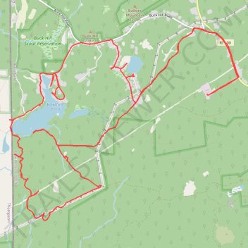
Burrillville Trails
- Distance: 24.3 Km
- Elevation gain: 302 m
- Maximum elevation: 220 m
- Elevation loss: 302 m
- Minimum elevation: 163 m
- Moving time: 2 h 31 m
- Moving speed: 9.6 Km/h
- Maximum speed: 17.4 Km/h
- Total time: 2 h 35 m
- Global speed: 9.4 Km/h
Interactive trail map
Trail profile
- Distance: 24.3 Km
- Elevation gain: 302 m
- Maximum elevation: 220 m
- Elevation loss: 302 m
- Minimum elevation: 163 m
- Moving time: 2 h 31 m
- Moving speed: 9.6 Km/h
- Maximum speed: 17.4 Km/h
- Total time: 2 h 35 m
- Global speed: 9.4 Km/h
About this trail
Name: Burrillville Trails trail, distance, elevation, map, profile, GPS track
Coordinates: 41.94665 -71.79881 41.97792 -71.74868