Thank you for supporting this site ❤️
Make a donation
Make a donation
Gear up for your next adventure:
As an Amazon Associate, this site earns from qualifying purchases at no extra cost to you.
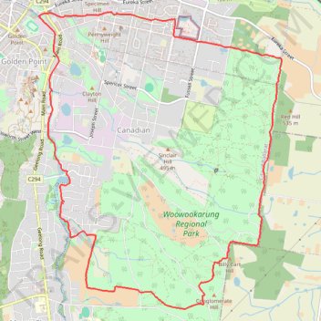
Hike Trace in Ballarat and Woowookarung Regional Park
- Distance: 14.9 Km
- Elevation gain: 191 m
- Maximum elevation: 542 m
- Elevation loss: 191 m
- Minimum elevation: 420 m
- Moving time: 2 h 53 m
- Moving speed: 5.1 Km/h
- Maximum speed: 9.5 Km/h
- Total time: 2 h 53 m
- Global speed: 5.1 Km/h
Interactive trail map
Thank you for supporting this site ❤️
Make a donation
Make a donation
Gear up for your next adventure:
As an Amazon Associate, this site earns from qualifying purchases at no extra cost to you.
Trail profile
- Distance: 14.9 Km
- Elevation gain: 191 m
- Maximum elevation: 542 m
- Elevation loss: 191 m
- Minimum elevation: 420 m
- Moving time: 2 h 53 m
- Moving speed: 5.1 Km/h
- Maximum speed: 9.5 Km/h
- Total time: 2 h 53 m
- Global speed: 5.1 Km/h
Thank you for supporting this site ❤️
Make a donation
Make a donation
Gear up for your next adventure:
As an Amazon Associate, this site earns from qualifying purchases at no extra cost to you.
About this trail
Name: Hike Trace in Ballarat and Woowookarung Regional Park trail, distance, elevation, map, profile, GPS track
Coordinates: -37.60490 143.86753 -37.56735 143.90626
Topography: Ballarat topographic map, elevation, terrain
Thank you for supporting this site ❤️
Make a donation
Make a donation
Gear up for your next adventure:
As an Amazon Associate, this site earns from qualifying purchases at no extra cost to you.
Other hiking, mountain biking, running and outdoor activity trails
Click on a trail to view its statistics, map and profile.
Woowookarung Regional Park Loop Hike
Australia > Victoria > Ballarat
Distance: 7.4 Km • Elevation gain: 131 m • Maximum elevation: 537 m