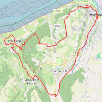
Honfleur Loop 19km
- Distance: 18.6 Km
- Elevation gain: 317 m
- Maximum elevation: 121 m
- Elevation loss: 318 m
- Minimum elevation: 4 m
Interactive trail map
Trail profile
- Distance: 18.6 Km
- Elevation gain: 317 m
- Maximum elevation: 121 m
- Elevation loss: 318 m
- Minimum elevation: 4 m
About this trail
Name: Honfleur Loop 19km trail, distance, elevation, map, profile, GPS track
Coordinates: 49.38217 0.16905 49.42392 0.23516
Other hiking, mountain biking, running and outdoor activity trails
Click on a trail to view its statistics, map and profile.
Trouville Honfleur 18km
France > Normandy > Calvados > Trouville-sur-Mer
Distance: 17.8 Km • Elevation gain: 413 m • Maximum elevation: 123 m
Cabourg Honfleur
France > Normandy > Calvados > Cabourg
Distance: 45.1 Km • Elevation gain: 564 m • Maximum elevation: 150 m
Honfleur Loop 19km
France > Normandy > Calvados > Honfleur
Distance: 18.6 Km • Elevation gain: 315 m • Maximum elevation: 121 m