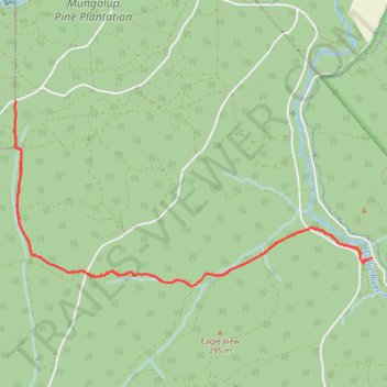
Wilman Bilya Trail
- Distance: 11.9 Km
- Elevation gain: 195 m
- Maximum elevation: 275 m
- Elevation loss: 192 m
- Minimum elevation: 173 m
- Moving time: 1 h 34 m
- Moving speed: 7.6 Km/h
- Maximum speed: 12.1 Km/h
- Total time: 1 h 37 m
- Global speed: 7.4 Km/h
Interactive trail map
Trail profile
- Distance: 11.9 Km
- Elevation gain: 195 m
- Maximum elevation: 275 m
- Elevation loss: 192 m
- Minimum elevation: 173 m
- Moving time: 1 h 34 m
- Moving speed: 7.6 Km/h
- Maximum speed: 12.1 Km/h
- Total time: 1 h 37 m
- Global speed: 7.4 Km/h
About this trail
Name: Wilman Bilya Trail trail, distance, elevation, map, profile, GPS track
End: Flora Road, Allanson, Collie, Shire Of Collie, Western Australia, Australia (-33.37099 116.09799)
Coordinates: -33.37366 116.05789 -33.35627 116.09799
Topography: Western Australia topographic map, elevation, terrain
Other hiking, mountain biking, running and outdoor activity trails
Click on a trail to view its statistics, map and profile.
Wiilman Bilya Trail section Connell road to west
Australia > Western Australia > Mungalup
Distance: 16.9 Km • Elevation gain: 258 m • Maximum elevation: 247 m