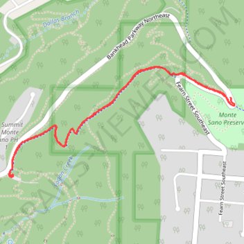
Toll Gate Greenway MTB in Monte Sano State Park
- Distance: 4.2 Km
- Elevation gain: 164 m
- Maximum elevation: 445 m
- Elevation loss: 158 m
- Minimum elevation: 316 m
- Moving time: 26 m 19 s
- Moving speed: 9.5 Km/h
- Maximum speed: 35.0 Km/h
- Total time: 31 m 12 s
- Global speed: 8.0 Km/h
Interactive trail map
Trail profile
- Distance: 4.2 Km
- Elevation gain: 164 m
- Maximum elevation: 445 m
- Elevation loss: 158 m
- Minimum elevation: 316 m
- Moving time: 26 m 19 s
- Moving speed: 9.5 Km/h
- Maximum speed: 35.0 Km/h
- Total time: 31 m 12 s
- Global speed: 8.0 Km/h
About this trail
Name: Toll Gate Greenway MTB in Monte Sano State Park trail, distance, elevation, map, profile, GPS track
Coordinates: 34.74358 -86.54462 34.74972 -86.52934
Other hiking, mountain biking, running and outdoor activity trails
Click on a trail to view its statistics, map and profile.
Bankhead Trail and Oak Park Trail MTB Ride in Monte Sano Nature Preserve
United States > Alabama > Madison County > Huntsville > Hawks Ridge
Distance: 4.5 Km • Elevation gain: 42 m • Maximum elevation: 412 m
25 mile Bike Ride, Huntsville/Gurley AL
United States > Alabama > Madison County > Huntsville > Five Points
Moontown Airport
Distance: 40.5 Km • Elevation gain: 377 m • Maximum elevation: 307 m
Land Trust Ride
United States > Alabama > Madison County > Huntsville
Distance: 19.0 Km • Elevation gain: 481 m • Maximum elevation: 494 m