Walk in Manhattan
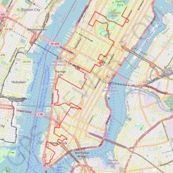
Interactive trail map
Trail profile
- Distance: 25.7 Km
- Elevation gain: 514 m
- Maximum elevation: 63 m
- Elevation loss: 557 m
- Minimum elevation: 0 m
About this trail
Name: Walk in Manhattan trail, distance, elevation, map, profile, GPS track
Coordinates: 40.70100 -74.01561 40.78110 -73.95942
Other hiking, mountain biking, running and outdoor activity trails
Click on a trail to view its statistics, map and profile.
Central Park Evening walk
United States > New York > New York County > New York
Distance: 3.8 Km • Elevation gain: 69 m • Maximum elevation: 49 m
New
United States > New York > New York County > New York
Distance: 88.5 Km • Elevation gain: 1,435 m • Maximum elevation: 63 m