Import a GPX file

Garnet Peak

Hike to Garnet Peak via the Pacific Crest Trail (PCT) and the Garnet Peak Trail in the Cleveland National Forest. #Hiking #Mountain #Nature

  • Distance: 3.3 Km
  • Elevation gain: 173 m
  • Maximum elevation: 1,775 m
  • Elevation loss: 70 m
  • Minimum elevation: 1,658 m

Interactive trail map

Trail profile

  • Distance: 3.3 Km
  • Elevation gain: 173 m
  • Maximum elevation: 1,775 m
  • Elevation loss: 70 m
  • Minimum elevation: 1,658 m

About this trail
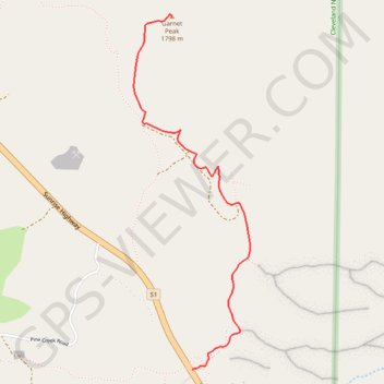
Name: Garnet Peak trail, distance, elevation, map, profile, GPS track

Start: 12027, Sunrise Highway, San Diego County, California, 91948, United States (32.90570 -116.45737)

End: Garnet Peak Trail, San Diego County, California, United States (32.92569 -116.45873)

Coordinates: 32.90570 -116.46130 32.92580 -116.45344

Other hiking, mountain biking, running and outdoor activity trails

Click on a trail to view its statistics, map and profile.
Monument Peak and Big Laguna Lake Loop

United States > California > San Diego County

Loop hike to Monument Peak via Big Laguna Lake, Pacific Crest National Scenic Trail (PCT) and Foster Point in the Cleveland National Forest and the Laguna Meadow. #Hiking #Loop #Mountain #Lake #Nature #PCT #Forest

Distance: 18.8 Km • Elevation gain: 538 m • Maximum elevation: 1,901 m

Epic Big Laguna Route

United States > California > San Diego County

Distance: 14.9 Km • Elevation gain: 342 m • Maximum elevation: 1,891 m

Gear up for your next adventure:

📚Map Reading & Navigation Guides - Master the art of interpreting topographic contours and symbols
🔪Outdoor Multi-tools - Versatile tools for gear repair and survival tasks in the wilderness
🕯️Emergency Whistles - Safety whistles for hiking
💧Personal Water Filters - Drink safely from streams and lakes identified on your map
🌿Flora and Fauna Field Guides - Identify the plants and animals you encounter on your route

As an Amazon Associate, this site earns from qualifying purchases at no extra cost to you.