McQueen Lake Red Loop Trail
- Distance: 2.8 Km
- Elevation gain: 75 m
- Maximum elevation: 1,009 m
- Elevation loss: 48 m
- Minimum elevation: 970 m
- Moving time: 1 h 19 m
- Moving speed: 2.1 Km/h
- Maximum speed: 6.8 Km/h
- Total time: 7 d 30 m
- Global speed: 0.0 Km/h
Interactive trail map
Trail profile
- Distance: 2.8 Km
- Elevation gain: 75 m
- Maximum elevation: 1,009 m
- Elevation loss: 48 m
- Minimum elevation: 970 m
- Moving time: 1 h 19 m
- Moving speed: 2.1 Km/h
- Maximum speed: 6.8 Km/h
- Total time: 7 d 30 m
- Global speed: 0.0 Km/h
About this trail
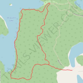
Name: McQueen Lake Red Loop Trail trail, distance, elevation, map, profile, GPS track
Coordinates: 50.82195 -120.44351 50.82928 -120.43417
Other hiking, mountain biking, running and outdoor activity trails
Click on a trail to view its statistics, map and profile.
McQueen Lake Red XC Trail
Canada > British Columbia > Thompson-Nicola Regional District > Area J (Copper Desert Country)
Distance: 2.0 Km • Elevation gain: 44 m • Maximum elevation: 1,009 m