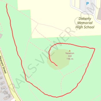
Newton Hill
- Distance: 0.9 Km
- Elevation gain: 8 m
- Maximum elevation: 196 m
- Elevation loss: 36 m
- Minimum elevation: 166 m
- Moving time: 15 m
- Moving speed: 3.7 Km/h
- Maximum speed: 5.2 Km/h
- Total time: 15 m
- Global speed: 3.7 Km/h
Interactive trail map
Trail profile
- Distance: 0.9 Km
- Elevation gain: 8 m
- Maximum elevation: 196 m
- Elevation loss: 36 m
- Minimum elevation: 166 m
- Moving time: 15 m
- Moving speed: 3.7 Km/h
- Maximum speed: 5.2 Km/h
- Total time: 15 m
- Global speed: 3.7 Km/h
About this trail
Name: Newton Hill trail, distance, elevation, map, profile, GPS track
Coordinates: 42.26603 -71.82377 42.26916 -71.81977
Other hiking, mountain biking, running and outdoor activity trails
Click on a trail to view its statistics, map and profile.
Loop in Eastern Mass involving various rail trails
United States > Massachusetts > Middlesex County > Newton
Distance: 203.8 Km • Elevation gain: 1,940 m • Maximum elevation: 194 m