Gedney Park West
- Distance: 3.9 Km
- Elevation gain: 119 m
- Maximum elevation: 170 m
- Elevation loss: 120 m
- Minimum elevation: 114 m
- Moving time: 50 m 41 s
- Moving speed: 4.6 Km/h
- Maximum speed: 14.3 Km/h
- Total time: 54 m 23 s
- Global speed: 4.3 Km/h
Interactive trail map
Trail profile
- Distance: 3.9 Km
- Elevation gain: 119 m
- Maximum elevation: 170 m
- Elevation loss: 120 m
- Minimum elevation: 114 m
- Moving time: 50 m 41 s
- Moving speed: 4.6 Km/h
- Maximum speed: 14.3 Km/h
- Total time: 54 m 23 s
- Global speed: 4.3 Km/h
About this trail
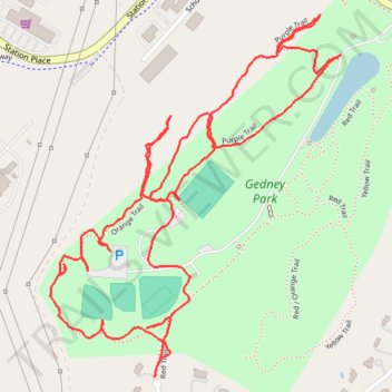
Name: Gedney Park West trail, distance, elevation, map, profile, GPS track
Coordinates: 41.18070 -73.80162 41.18788 -73.79397
Other hiking, mountain biking, running and outdoor activity trails
Click on a trail to view its statistics, map and profile.
Gedney Park East
United States > New York > Westchester County > Millwood
Distance: 3.1 Km • Elevation gain: 53 m • Maximum elevation: 146 m
Gedney Park Central
United States > New York > Westchester County > Millwood
Distance: 1.9 Km • Elevation gain: 26 m • Maximum elevation: 134 m