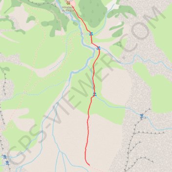
Day 4 Gavarnie from Hotellerie to Grande Cascade
- Distance: 1.2 Km
- Elevation gain: 216 m
- Maximum elevation: 1,787 m
- Elevation loss: 0 m
- Minimum elevation: 1,570 m
Interactive trail map
Trail profile
- Distance: 1.2 Km
- Elevation gain: 216 m
- Maximum elevation: 1,787 m
- Elevation loss: 0 m
- Minimum elevation: 1,570 m
About this trail
Name: Day 4 Gavarnie from Hotellerie to Grande Cascade trail, distance, elevation, map, profile, GPS track
Coordinates: 42.69491 -0.00806 42.70411 -0.00593
Other hiking, mountain biking, running and outdoor activity trails
Click on a trail to view its statistics, map and profile.
GR 10 - Traversée des Pyrénées
France > Occitania > Pyrénées-Orientales > Banyuls-sur-Mer
Distance: 874.8 Km • Elevation gain: 57,000 m • Maximum elevation: 2,599 m
Southern section — European Divide Trail
France > Auvergne-Rhône-Alpes > Drôme > Valence
Distance: 2,423.8 Km • Elevation gain: 42,375 m • Maximum elevation: 2,005 m
1 LUCENA - MONTPELLIER
Distance: 2,964.4 Km • Elevation gain: 29,500 m • Maximum elevation: 1,048 m