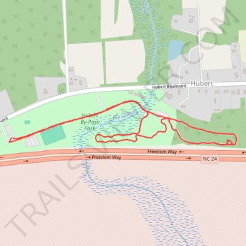
Hubert By-Pass Park Loop Walk
- Distance: 2.9 Km
- Elevation gain: 6 m
- Maximum elevation: 14 m
- Elevation loss: 6 m
- Minimum elevation: 9 m
- Moving time: 39 m 22 s
- Moving speed: 4.5 Km/h
- Maximum speed: 6.9 Km/h
- Total time: 39 m 53 s
- Global speed: 4.4 Km/h
Interactive trail map
Trail profile
- Distance: 2.9 Km
- Elevation gain: 6 m
- Maximum elevation: 14 m
- Elevation loss: 6 m
- Minimum elevation: 9 m
- Moving time: 39 m 22 s
- Moving speed: 4.5 Km/h
- Maximum speed: 6.9 Km/h
- Total time: 39 m 53 s
- Global speed: 4.4 Km/h
About this trail
Name: Hubert By-Pass Park Loop Walk trail, distance, elevation, map, profile, GPS track
Start: Hubert Boulevard, Hubert, Onslow County, North Carolina, 28539, United States (34.71163 -77.25424)
End: Hubert Boulevard, Hubert, Onslow County, North Carolina, 28539, United States (34.71163 -77.25417)
Coordinates: 34.71137 -77.25436 34.71307 -77.24357