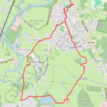
Colden Common to Stoke Woods Loop
Loop hike from Colden Common via Colden Common Recreation Ground, The Green, Brambridge, Highbridge, Stoke Common Copse, Bowlake Copse, Stoke Park Farm and Leylands Farm. #Hiking #Loop #CountrySide #Park #Nature #Forest
- Distance: 7.7 Km
- Elevation gain: 80 m
- Maximum elevation: 50 m
- Elevation loss: 80 m
- Minimum elevation: 13 m
- Moving time: 1 h 40 m
- Moving speed: 4.5 Km/h
- Maximum speed: 7.6 Km/h
- Total time: 1 h 50 m
- Global speed: 4.1 Km/h
Interactive trail map
Trail profile
- Distance: 7.7 Km
- Elevation gain: 80 m
- Maximum elevation: 50 m
- Elevation loss: 80 m
- Minimum elevation: 13 m
- Moving time: 1 h 40 m
- Moving speed: 4.5 Km/h
- Maximum speed: 7.6 Km/h
- Total time: 1 h 50 m
- Global speed: 4.1 Km/h
About this trail
Name: Colden Common to Stoke Woods Loop trail, distance, elevation, map, profile, GPS track
Coordinates: 50.97952 -1.33395 51.00058 -1.31188