Thank you for supporting this site ❤️
Make a donation
Make a donation
Gear up for your next adventure:
As an Amazon Associate, this site earns from qualifying purchases at no extra cost to you.
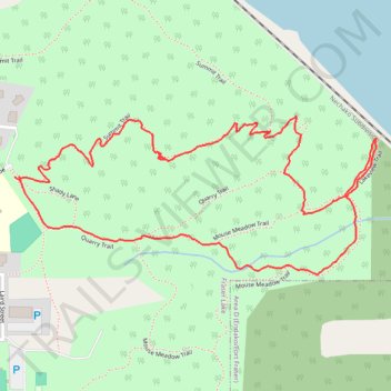
2026-06-01_12-25_Mon
- Distance: 2.7 Km
- Elevation gain: 137 m
- Maximum elevation: 807 m
- Elevation loss: 138 m
- Minimum elevation: 678 m
- Moving time: 52 m 38 s
- Moving speed: 3.1 Km/h
- Maximum speed: 8.9 Km/h
- Total time: 1 h 23 m
- Global speed: 1.9 Km/h
Interactive trail map
Thank you for supporting this site ❤️
Make a donation
Make a donation
Gear up for your next adventure:
As an Amazon Associate, this site earns from qualifying purchases at no extra cost to you.
Trail profile
- Distance: 2.7 Km
- Elevation gain: 137 m
- Maximum elevation: 807 m
- Elevation loss: 138 m
- Minimum elevation: 678 m
- Moving time: 52 m 38 s
- Moving speed: 3.1 Km/h
- Maximum speed: 8.9 Km/h
- Total time: 1 h 23 m
- Global speed: 1.9 Km/h
Thank you for supporting this site ❤️
Make a donation
Make a donation
Gear up for your next adventure:
As an Amazon Associate, this site earns from qualifying purchases at no extra cost to you.
About this trail
Name: 2026-06-01_12-25_Mon trail, distance, elevation, map, profile, GPS track
Coordinates: 54.05906 -124.83675 54.06203 -124.82517
Thank you for supporting this site ❤️
Make a donation
Make a donation
Gear up for your next adventure:
As an Amazon Associate, this site earns from qualifying purchases at no extra cost to you.