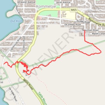
Kommetjie
- Distance: 2.9 Km
- Elevation gain: 171 m
- Maximum elevation: 151 m
- Elevation loss: 149 m
- Minimum elevation: 9 m
- Moving time: 1 h 14 m
- Moving speed: 2.4 Km/h
- Maximum speed: 39.2 Km/h
- Total time: 1 h 42 m
- Global speed: 1.7 Km/h
Interactive trail map
Trail profile
- Distance: 2.9 Km
- Elevation gain: 171 m
- Maximum elevation: 151 m
- Elevation loss: 149 m
- Minimum elevation: 9 m
- Moving time: 1 h 14 m
- Moving speed: 2.4 Km/h
- Maximum speed: 39.2 Km/h
- Total time: 1 h 42 m
- Global speed: 1.7 Km/h
About this trail
Name: Kommetjie trail, distance, elevation, map, profile, GPS track
Coordinates: -34.14862 18.32054 -34.14300 18.33547