Mount Willard
Interactive trail map
Trail profile
- Distance: 5.0 Km
- Elevation gain: 309 m
- Maximum elevation: 848 m
- Elevation loss: 309 m
- Minimum elevation: 575 m
About this trail
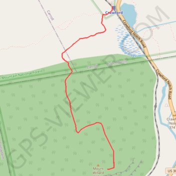
Name: Mount Willard trail, distance, elevation, map, profile, GPS track
Start: Avalon Trail, Carroll, Coös County, New Hampshire, United States (44.21798 -71.41148)
End: Avalon Trail, Carroll, Coös County, New Hampshire, United States (44.21798 -71.41148)
Coordinates: 44.20358 -71.41772 44.21798 -71.41131
Other hiking, mountain biking, running and outdoor activity trails
Click on a trail to view its statistics, map and profile.
Mount Willard Trail in White Mountain National Forest
United States > New Hampshire > Coos County > Carroll
The Mount Willard Trail provides an accessible yet rewarding hike with exceptional views. As you ascend, you pass through a fragrant forest, encountering small waterfalls and serene pools before reaching a rocky, steeper section that leads to the summit. At the top, the panoramic vista of Crawford Notch and…
Distance: 5.1 Km • Elevation gain: 301 m • Maximum elevation: 849 m
Mount Field, Mount Willey, Mount Avalon and Mount Tom Loop
United States > New Hampshire > Coos County > Carroll
Loop hike from Sako Lake via Avalon Trail, Mount Avalon, Mount Field, Willey Range Trail, Mount Willey, Mount Tom Spur, Mount Tom and A-Z Trail in the White Mountain National Forest. #Hiking #Loop #Mountain #Nature #Forest #Lake
Distance: 15.2 Km • Elevation gain: 1,021 m • Maximum elevation: 1,299 m