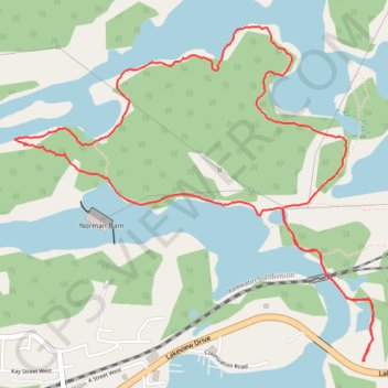
Tunnel Island Loop - Bison Trail A
- Distance: 6.4 Km
- Elevation gain: 116 m
- Maximum elevation: 347 m
- Elevation loss: 116 m
- Minimum elevation: 316 m
- Moving time: 1 h 53 m
- Moving speed: 3.4 Km/h
- Maximum speed: 6.9 Km/h
- Total time: 2 h 17 m
- Global speed: 2.8 Km/h
Interactive trail map
Trail profile
- Distance: 6.4 Km
- Elevation gain: 116 m
- Maximum elevation: 347 m
- Elevation loss: 116 m
- Minimum elevation: 316 m
- Moving time: 1 h 53 m
- Moving speed: 3.4 Km/h
- Maximum speed: 6.9 Km/h
- Total time: 2 h 17 m
- Global speed: 2.8 Km/h
About this trail
Name: Tunnel Island Loop - Bison Trail A trail, distance, elevation, map, profile, GPS track
Coordinates: 49.76595 -94.52953 49.77932 -94.50732
Other hiking, mountain biking, running and outdoor activity trails
Click on a trail to view its statistics, map and profile.
Whiteshell - Kenora
Canada > Unorganized Division No. 1
#Bike #Whiteshell #Kenora
Distance: 69.2 Km • Elevation gain: 577 m • Maximum elevation: 382 m