Import a GPX file

Long Pond and Happy Marsh loop trail in Widewater State Park

  • Distance: 4.2 Km
  • Elevation gain: 40 m
  • Maximum elevation: 11 m
  • Elevation loss: 40 m
  • Minimum elevation: -1 m
  • Moving time: 1 h 31 m
  • Moving speed: 2.8 Km/h
  • Maximum speed: 3.8 Km/h
  • Total time: 1 h 54 m
  • Global speed: 2.2 Km/h

Interactive trail map

Trail profile

  • Distance: 4.2 Km
  • Elevation gain: 40 m
  • Maximum elevation: 11 m
  • Elevation loss: 40 m
  • Minimum elevation: -1 m
  • Moving time: 1 h 31 m
  • Moving speed: 2.8 Km/h
  • Maximum speed: 3.8 Km/h
  • Total time: 1 h 54 m
  • Global speed: 2.2 Km/h

About this trail
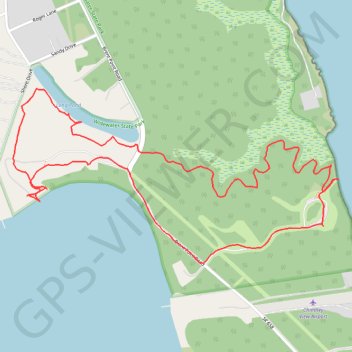
Name: Long Pond and Happy Marsh loop trail in Widewater State Park trail, distance, elevation, map, profile, GPS track

Start: Canoe Launch, Shore Drive, Widewater Beach, Stafford County, Virginia, 22554, United States (38.40714 -77.32753)

End: Canoe Launch, Shore Drive, Widewater Beach, Stafford County, Virginia, 22554, United States (38.40716 -77.32768)

Coordinates: 38.40502 -77.32824 38.41056 -77.31502

Gear up for your next adventure:

🦯Trekking Poles - Walking poles for hiking stability
🥾Heavy Duty Hiking Boots - Ankle-supporting boots for carrying heavy packs on steep contours
🖼️Scratch-off Australia Map - Track the regions and peaks you have explored geographically
☀️Portable Solar Chargers - High-efficiency panels to hang on your backpack while walking
📍Handheld GPS - GPS devices for hiking and navigation

As an Amazon Associate, this site earns from qualifying purchases at no extra cost to you.