Around Meikleour
Mountain Bike Ride
- Distance: 6.6 Km
- Elevation gain: 123 m
- Maximum elevation: 137 m
- Elevation loss: 36 m
- Minimum elevation: 48 m
- Moving time: 30 m 51 s
- Moving speed: 12.9 Km/h
- Maximum speed: 22.5 Km/h
- Total time: 38 m 58 s
- Global speed: 10.2 Km/h
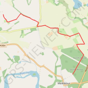
Interactive trail map
Trail profile
- Distance: 6.6 Km
- Elevation gain: 123 m
- Maximum elevation: 137 m
- Elevation loss: 36 m
- Minimum elevation: 48 m
- Moving time: 30 m 51 s
- Moving speed: 12.9 Km/h
- Maximum speed: 22.5 Km/h
- Total time: 38 m 58 s
- Global speed: 10.2 Km/h
About this trail
Name: Around Meikleour trail, distance, elevation, map, profile, GPS track
Start: A984, Meikleour, Perth and Kinross, Scotland, PH2 6DZ, United Kingdom (56.54361 -3.36480)
End: B947, Kirkton of Lethendy, Perth and Kinross, Scotland, PH2 6EF, United Kingdom (56.56683 -3.41389)
Coordinates: 56.54361 -3.41389 56.56717 -3.35648
Other hiking, mountain biking, running and outdoor activity trails
Click on a trail to view its statistics, map and profile.
Inchtuthil Roman Legionary Fortress
United Kingdom > Scotland > Perth and Kinross > Newlands
Inchtuthil Redoubt
Distance: 13.9 Km • Elevation gain: 130 m • Maximum elevation: 97 m
Black Hill Roman Watch Tower - Around Meikleour, Perthshire
United Kingdom > Scotland > Perth and Kinross > Newlands
Distance: 19.4 Km • Elevation gain: 246 m • Maximum elevation: 138 m
Kinclaven Wood - Stanley - Bankfoot Loop
United Kingdom > Scotland > Perth and Kinross > Newlands
Distance: 43.0 Km • Elevation gain: 547 m • Maximum elevation: 137 m
Around Spittalfield, Scotland
United Kingdom > Scotland > Perth and Kinross
Distance: 19.1 Km • Elevation gain: 278 m • Maximum elevation: 137 m
King's Myre Loop
United Kingdom > Scotland > Perth and Kinross > Newlands
Distance: 39.8 Km • Elevation gain: 365 m • Maximum elevation: 106 m