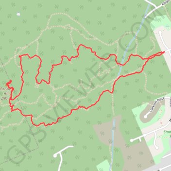
Import a GPX file

Broom Hill Loop

Vancouver Island. #Hiking #Running #Loop #BroomHill #Vancouver

  • Distance: 5.1 Km
  • Elevation gain: 202 m
  • Maximum elevation: 273 m
  • Elevation loss: 202 m
  • Minimum elevation: 103 m

Interactive trail map

Trail profile

  • Distance: 5.1 Km
  • Elevation gain: 202 m
  • Maximum elevation: 273 m
  • Elevation loss: 202 m
  • Minimum elevation: 103 m

About this trail

Gear up for your next adventure:

🧼Biodegradable Soap - Eco-friendly outdoor soap
📚Map Reading & Navigation Guides - Master the art of interpreting topographic contours and symbols
💧Personal Water Filters - Drink safely from streams and lakes identified on your map
🖼️Scratch-off Australia Map - Track the regions and peaks you have explored geographically
🧺Waterproof Dry Sacks - Organize your pack and keep electronics safe from rain and river crossings

As an Amazon Associate, this site earns from qualifying purchases at no extra cost to you.